Third Rock From the Sun: Exploring Ladakh With the NASA Crew
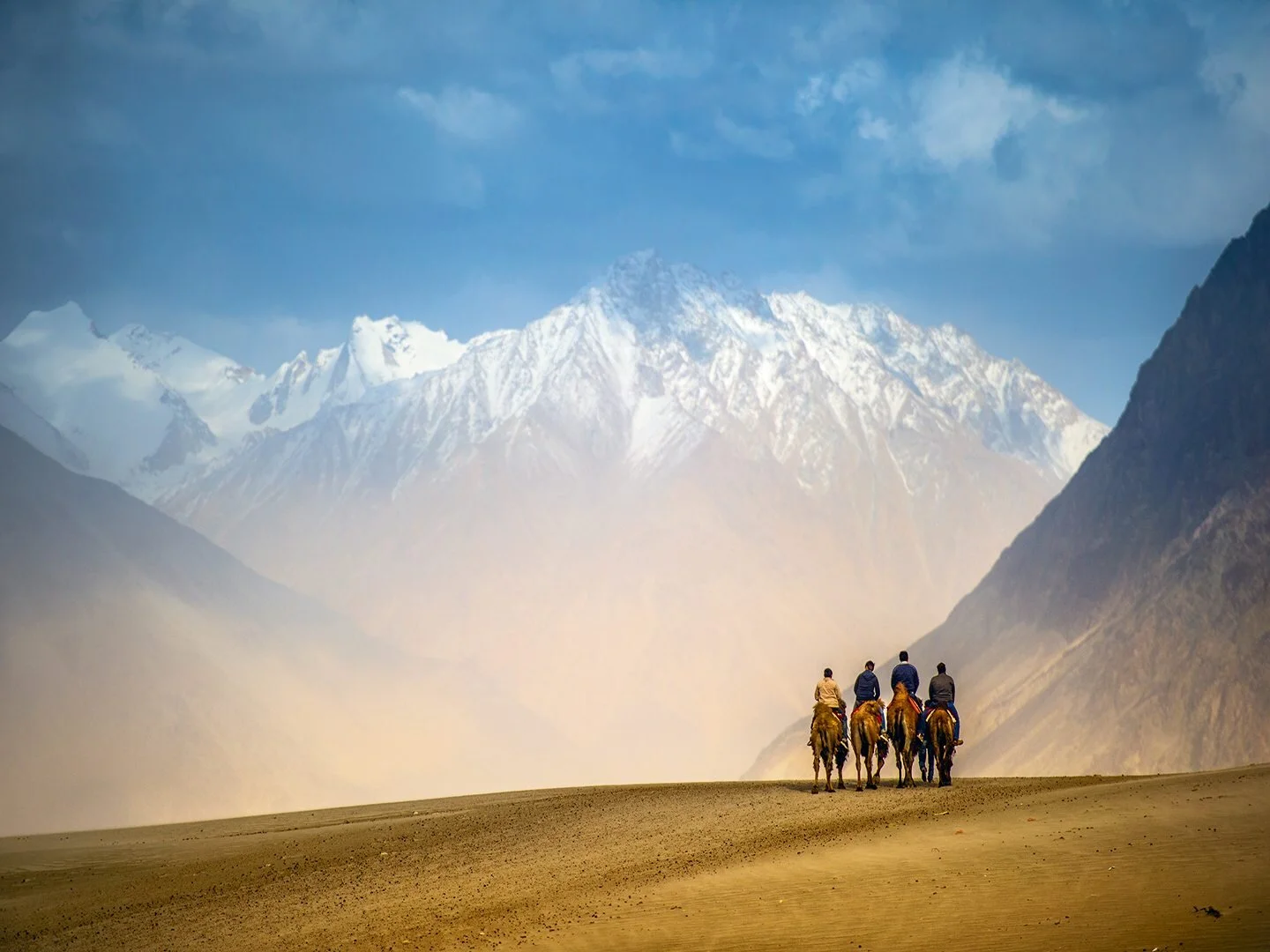
Located close to the confluence of the Nubra and Shyok Rivers, the Hunder sand dunes seem out of place in Ladakh’s cold, mountainous Nubra Valley. Bactrian camels, native to this area, glide across the sands with snowy peaks looming in the distance. Photo: skaman306/Moment Open/Getty Images
Published in National Geographic Traveller India - January 2017
“Don’t cry,” I told myself as the setting sun bathed the snow-capped Himalayan peaks in front of me in shades of dull gold. Puffy grey clouds punctuated the darkening blue sky, whilst Tso Moriri Lake shimmered like a diamond covered blanket in the mountain’s shadow. I couldn’t help but be overwhelmed in that moment.
It wasn’t the first time I’d teared up on encountering such raw, audacious natural beauty on this trip through Ladakh. Towering mountains, roaring rivers, impossibly vast valleys—it’s like this place was made with magic. Dumbstruck as the landscape left me, I was also in awe of what the unique geographical features revealed about the region.
I was exploring Ladakh as a member of the NASA Spaceward Bound India (SBI) team—a motley crew of scientists, researchers, and educators from around the world who were in the region to study terrains and environments that could resemble Mars. While the team looked for locations and formations that were analogous to the Red Planet, I was keen to understand the region differently, to learn about Ladakh through its rivers, lakes, mountains, glaciers, and valleys.
“I calculated that when we were at Khardung La, half of the planet’s atmosphere was below us,” Sanjoy Som said the evening after we’d driven along the “world’s highest motorable road” to get from Leh to the Nubra Valley. Sanjoy is a California-based research scientist.

The perilous road up to Khardung La is a very popular route with bikers from across the world. Photo: Didier Martin/MomentOpen/Getty Images
My mind went back to our journey up to Khardung La earlier that day. Our vehicles had followed a barely-there road that clung to the side of a mountain as it rose above the valley. Leather-clad bikers vroomed past us like a swarm of purposeful drones, their bikes festooned with colourful Buddhist prayer flags. There was even the occasional bicyclist who huffed and puffed his way up to the top.
As we climbed steadily from Leh’s comfortable altitude of 11,000-odd feet to Khardung La’s dizzying 18,380 feet, I saw the Leh valley unfurl below me. In the distance, green clumps of elegant, swaying poplar trees pinpointed settlements at Stok. The imposing mountain peaks that had once made us squint as we looked up at them were now at eye level, disappearing into the distance in varying shades of brown, blue, and deep purple.
Nose pressed against the window, I was so enamoured by the landscape that I almost missed Sanjoy’s explanation of how the Khardung Glacier had carved out the valley we were driving through. We had just turned a treacherously tight corner when a large sheet of greyish-white ice came into view. Like ice cream dripping off a cone, it seemed to flow from a mountaintop, and didn’t look very formidable. But my perception changed when the glacier was described as a massive bulldozing machine that ruthlessly cut through mountains thousands of years ago: It is actually a lethal, roiling mix of ice and stone that steamrolls over whatever stands in its path.
Sanjoy showed me how to spot clues about the valley’s origins. The valley’s U-shape is the first indicator that it is a glacier’s work, as opposed to V-shaped valleys formed by rivers. Then there are the large, angular rocks that anybody who travels to Khardung La sees by the road. They’re called erratics and were left behind by the retreating glacier. They’re unlike river rocks, which are smaller, rounder, and smoother.
The last clue is in the road’s winding route up to Khardung La. It follows a semi-circular ridge that encloses a pocket of emerald trees and a small village. This ridge, called terminal moraine, marks the point where the glacier finally stopped pushing forward. Imagine running a finger through wet sand. As you drag it forward, you carry sand with you, while displacing some on the sides. The mounds on the side are lateral moraine; and the one that forms where you stop dragging your finger is the terminal moraine. Khardung Glacier’s terminal moraine becomes more distinct the higher the road goes.

Nubra Valley’s rugged beauty is punctuated by two massive rivers: the Nubra and the Shyok. In summer, some sections gleam aquamarine, others resemble muddy brown streams, heavy with silt and deposits. Photo: Devilkae/iStock
We continued to decode the landscape after we crossed Khardung La and descended into the Nubra Valley. As we began following the Shyok River, I noticed small channels of water intertwining together to form the river. They gleamed brightly in the afternoon sun, like thick silver ropes. However, what I saw as a beautifully braided river was to Sanjoy a sign that there isn’t enough vegetation along the banks to anchor the soil. This could be a result of Ladakh’s dry climate, he said, and the high sediment load of the river that washes away or buries plants before they have a chance to get a foothold.
Later that evening, as we sipped chai at our hotel in Nubra, I learned that many parts of Ladakh were once underwater. The Tethys Sea was a waterbody that, in the past, separated the Indian and Eurasian continental plates. But about 50 million years ago, those two plates crashed into each other, pushing sediment and debris up from the seabed towards the planet’s surface. A byproduct of that occurrence was the rise of the Himalayas. Ancient marine fossils like ammonites found all along the slopes of these mountains in Ladakh, even near some summits, further prove that this land was once underwater.
I began to realize what a geological goldmine this region is. As Sanjoy put it: Rocks are the history books of the planet, and if you can read them, it’s the greatest story ever told.
Our minivan trundled alongside the muddy Shyok River and the yawning Nubra Valley opened up ahead. Mountains loomed around us like ancient sentinels, stretching to the horizon with their snowy peaks. Clouds resembled giant helium-filled balloons that changed shape from elephants to castles in a matter of minutes. The deeper we drove into the valley, the wider it got. Monasteries and villages on the other side resembled the tiny Polly Pocket doll’s houses I played with as a child. At its widest the Nubra Valley is about ten kilometres across.
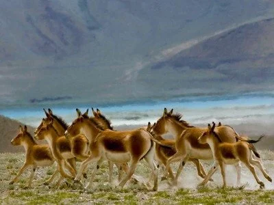
A variety of wild ass roam the Tso Kar basin. They are often spotted munching on grass, and some even run alongside vehicles driving through the basin. Photo: Discover the natural beauty.Naturecreatesmagic/Moment Open/Getty Images
Like the Khardung Valley, Nubra also has glacial origins—the Siachen Glacier sits at the valley’s northern end. The massive ice sheet, infamous after the 1999 Kargil War as the world’s highest battlefield, thrust through the mountains to create the valley. Today, the glacier is about 76 kilometres in length, but in the past it stretched approximately 90 kilometres southeast to reach the confluence of the Nubra and Shyok Rivers (the two main rivers of the valley). As it pushed its way down, it sheared mountainsides and scooped out chunks of rocks, leaving behind what we see today.
Nubra is filled with fascinating natural wonders, but what I was most excited about were the Panamik hot springs and the two-humped camels that roam the Hunder sand dunes.
Like the Himalayas around us, the hot springs are another sign of the continental plate clash that started millions of years ago. There continues to be a lot of underground tectonic activity in this region, and all that rumbling and shaking heats up subterranean water sources, increasing pressure and forcing the liquid up to the surface, like at Panamik. Tourists can visit these springs, and even bathe in the waters.
I’d imagined the Panamik hot springs to be large pools of boiling water rising up from the earth’s depths. Instead, I saw a narrow stream of water running down a hillside, with a few small pools at the top where the springs emerged. It didn’t look impressive, but I could feel the steam rising as I placed my hand just above the water—the average temperature was in the low 70s°C.
Another bit of geographical Sherlocking with Sanjoy livened the place up. Parts of the stream bed were covered in a green film created by microbes living in those patches. The green indicated photosynthesis, and the patches were a clue that the water’s temperature is no higher than about 75°C; anything warmer would be too hot for photosynthesis to take place.
Unlike the hot springs, the two-humped camels I spotted were just like the pictures I’d seen. Gliding along the Hunder dunes they looked like something out of a Lewis Carroll story and completely out of place in a region of ice-covered mountains.
Hunder’s crescent-shaped dunes are located near the confluence of the Nubra and Shyok Rivers, and are surrounded by skyscraping mountains. The sand is brought here by winds that pick up the fine particles from across the valley. As the winds change, so do the dunes. Jon Clarke, a geologist from Australia, believes this could shed light on how Martian dunes are formed, since similar formations are seen on the Red Planet.

Millions of years ago, Ladakh was part of a submarine landscape called the Tethys Sea, traces of which can be found across the region. Ammonite fossils, representing mollusc like creatures that once swam the oceans, are a prime example of that. Photo: Taylor Weidman/LightRocket/Getty Images
While I was scouring the sands for camels, Jon was on his own quest. Soon he called out to a couple of us, pointing at canoeshaped outcrops of sedimentary deposits that he had found in between the dunes. These deposits, made of layers of mud and sand, had a hard, cracked surface, like a dried pond, and some even had impressions of hoofprints. Jon wasn’t sure how old the hoofprints were, and said nothing about dinosaurs, but that didn’t stop the theme song of Jurassic Park from playing in my head. What he did know was that these depressions in the sand once held water. The layers of deposits in the formation meant that the process of accumulation was cyclical and the prints indicate that animals once came here for something, most likely to quench their thirst.
It took me a few moments to process the information. As I played back Jon’s words in my mind I looked around me, at the biscuit-coloured dunes and the snowy peaks in the distance. It felt like all my geography lessons were coming to life here. And as grateful as I was for seeing these stunning landscapes in person, I was equally thankful to the SBI team who helped me decode the past of these places.
Ladakh’s lakes are famous for their vivid blue waters and the perfect backdrop they form to guarantee memorable Facebook pictures. And like the region’s mountains and valleys, its lakes are great indicators of its past.
Tso Kar is one of Ladakh’s lesser-visited lakes, about 150 kilometres south of Leh. A small bumpy road leads to a vast basin once filled with water. It is surrounded by chocolate-coloured mountains. Today it is largely dry, with patches of scrub and grass covering parts of the basin. Wild ass or kiang roam freely, leisurely grazing and stopping to stare at cars driving by. A strong wind blows most of the day and night, carrying fine sand with it. Maybe this is what parts of Mars could be like. Minus the kiang, of course.
When I visited, the eastern end of the Tso Kar basin had some water, while the western edge near our camp was dry. Jon pointed out vague horizontal lines on the surrounding mountain slopes, like bathtub rings that told us how high the lake used to be. One way to spot these lines, especially near water bodies, is to look out for slight colour variations on hills or mountains. Often the parts below the line, that were more recently submerged, might be a lighter shade than the areas above the line which could be darker due to longer exposure to the elements.
These impressions of lines and sediments can be seen in many parts of Ladakh. Near the Spituk monastery in Leh, remnants of a massive lake are seen as pale yellow-brown patches. Binita Phartiyal, a geologist working in Lucknow, analysed the sedimentary layers in these patches and dated the base to about 10,000 years ago, and the uppermost section as 1,500 years old. Which means that 15 centuries or so ago, parts of Leh Valley were submerged by a waterbody.

The writer was part of the NASA Spaceward Bound India team which had scientists from around the world. In Ladakh’s arid environment European scientists (left) test the scientific instrument they intend to send to Mars; The NASA SBI team taught local schoolchildren (right) how to launch handmade rockets with the help of plastic pipes and a bicycle pump. Photo: Rakesh Rao
Varying lake levels also indicate how the area’s climate has changed. Glacial streams and rivers feed many of these lakes. But due to global warming, glaciers haven’t been getting enough snow, thus shrinking in size and leading to less water being pumped into the lakes.
Exposed sedimentary deposits, like the ones at Spituk, also highlight climatic events. Thick layers of deposits could mean that a storm or a flood brought the sediments in one go, while repetitive ones, like Jon’s find at Hunder, highlight repetitive cycles.
There’s also an interesting non-geological way to think about changing water levels—by the locations of monasteries. Today, it might seem like these buildings were built at a height, but that may not have been the case hundreds of years ago. Given how much the waterbodies of Ladakh have changed, it’s possible that when built, these monasteries were along riverbanks and lakeshores. Some of them even have murals depicting monks crossing waterbodies in boats.
On my last night in Leh, I was looking up at the sky, hoping for a clear view of the Milky Way. I wanted to see our galaxy while in Ladakh and this was my last chance. I’ve grown up staring slack-jawed at the stars, wondering what lay beyond. The cosmos’s vastness makes me feel small, and puts my silly whining into perspective. After all, what is the temporary angst of an unreplied text message compared to the sustained fury of a storm that has been raging on Jupiter for centuries?
As I scanned the heavens, my eyes fell on the silhouettes of the silent mountains around that have watched the planet change over millions of years. I realized that the mountains made me feel just like the universe does: humbled. My time in Ladakh helped me see that Earth has enough wonders to silence any crises, existential or otherwise, that I might have. All I have to do is open my eyes just a little bit wider.